Σταχυολογούμε από εδώ. Έχει ενδιαφέρον γιατί αντιλαμβάνεται κανείς ποιοι κοινωνικοί ρόλοι αμφισβητήθηκαν και τι παρέμεινε “κανονικό”.
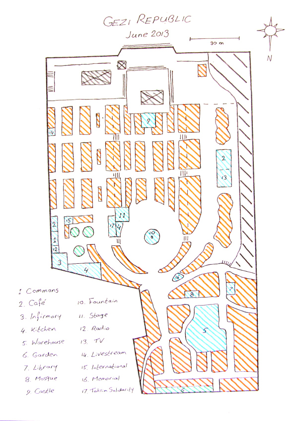
The park is divided into three.
Uptown is made up of the main platform facing Taksim square. It housed almost exclusively political stands and a Kurdish corner.
Midtown features a central rectangle, like a bath tub, flanked by an elevated East and West side. The Central Park was a mix of residential zones and socio-political stands. It’s characterised by the big square with the Fountain (10) and the children’s Castle (9).
The East Side is mainly residential. As a livestreaming collective, we had our base camp on the Upper East Side, at the intersection of Tenth Avenue and Second Street (14). For me personally, my secondary base was the International Corner, which I co-founded on Fourth Street (15). This area, the Lower East Side, was the core of the park, both logistically and politically. It housed the Commons, the Infirmary, the Kitchen, the Çapulçu Cafe and the Radio (1,2,3,4,12). It was also home to the Stage (11), which was controlled by Taksim Solidarity (17).
The West side was dominated by the fixed structured of what used to be a cafe, and what was turned into the Television studio of Çapulçu TV once it was occupied (13). Behind it, there was a natural border in the form a Grand Canyon leading down to the reconstruction site of Taksim square. Compared to the rest of the park, the far West Side was made up of slums.
At the border between the central square and downtown, a Memorial had been erected in honour of those who died (16). It consisted of the text ‘Taksim to the People’, dotted with candles that were lit every evening at nightfall.
Downtown differs from the rest of Gezi Park because of the organic layout of the streets as opposed to the rational Roman/American style city grid in Midtown. The heart of Downtown was entirely taken up by the central Warehouse (5), which collected and distributed all necessary medical, food and other supplies that were donated by the people of Istanbul and the rest of the world. Main features of Downtown, aside from the Victory garden, were the Library (7), built in the form of a fortress, and the Mosque (8), made from two party tents. At the exit of the park behind the Library there was also a subway station.
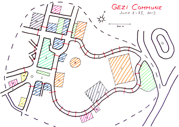
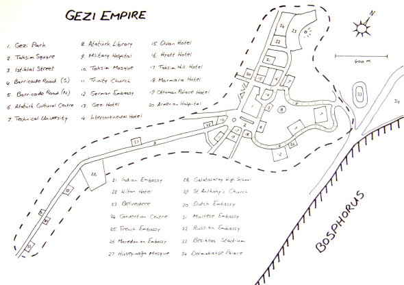
The Gezi Republic and Taksim Square were only a small part of the greater Gezi Empire, more commonly known as the ‘Gezi Commune’. The entire area under popular control from June 3 to June 11 went from the end of Istiklal street down to the Beşiktaş stadium and up to the panoramic terrace of the Hilton Hotel.
To picture this, bear in mind the geographical configuration of central Istanbul. Taksim Square is on a hill. And Gezi park is like a fortress on a hill. After the people conquered the square on June 1, clashes with police continued for two more days on the roads leading down to the waterfront. These clashes were spearheaded by Çarşı, the anarchist hard core of the Beşiktaş fans, aided by Kurds and transsexuals.
On June 3, police forces were beaten back to the prime minister’s weekend office in the Dolmabahçe palace on the shore of the Bosphorus. The insurgents conquered one bulldozer, two water cannons and three police buses (which they burned and used as barricades), plus countless shields, gear, gas masks and police cars. In the evening of June 3, the Gezi Commune was a fact.
At its height, the Commune encompassed, at the very least, one university (with two campuses), one high school, two hospitals, one cultural centre, one library, one convention centre, two mosques (not including the one in Gezi Park), two churches, seven consolates (upgraded to full scale embassies for the occasion) and eight luxury hotels.
Suburbs of Gezi park (in light green), with tents or stands, were located in Taksim Square to the south, in the park between the Divan and Hyatt hotels in the north, next to the Technical University in the northeast, and on the hill opposite the Beşiktaş stadium in the east.
The defense of the Gezi Commune depended on the barricades. Three of these were made up of burned police buses. One on the East side of the park, one next to the Intercontinental, where the mobile toilets were placed, and one between the Technical University and the Hyatt hotel.
By far the most barricades, twenty-three lines in total between main and supply barricades, were located on the roads leading down to the sea, where the battle had taken place. Aside from those, all exits to Taksim had been barred, except for Istiklal street. It was a fundamental weak spot in the defense of the Commune, but it was necessary to have a life line through which ambulances, garbage trucks and supply vehicles could enter. To this effect, the barricades on the northeast side could be opened, so that the wounded from the infirmary could be quickly evacuated.
The barricades were manned twenty four hour a day, mostly by anarchist football fans, but also by communists and nationalists. The easternmost suburb of Gezi, opposite the Beşiktaş stadium, was home to dozens of people who acted as an early warning system in case of a police attack from Dolmabahçe palace.


Pingback: Die Gezi Commune « Les Camarades Imaginaires